Marco Viganò, 24 febbraio 2020
A note for Scholar Ahmed Zakaria, visiting Napoli Orientale University,
—————
1. A welcome request from a Heritage Management activist
Noted Ethiopisant Ahmed, former curator of the IES museum in Addis will be briefly visiting Napoli University this April, 2018. He asked me to prepare a note on the discoveries remote sensing has permitted these latter years, major sites tied to the period preceding the Ethio Adal vast scale and lasting conflict of the XVI century. I have decided to present here the military structures found, first.
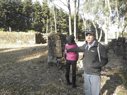
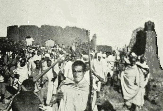
Ahmed Zakaria actively saved the walls of Harar. As a young man, he rallied his neighbors and managed to raise some funds, to totally dispel the then ongoing destruction of the completely walled city, the only one of the kind known in continental sub-Saharan Africa. He promoted a successful reconstruction of the then partly demolished enclosure, prompting and participating in the recognition of Harar as a World Heritage Site1. Those walls were the direct result of the aftermath of the early XVI century Ethio Adal war. A yet winning Adal side, after long war distress found it necessary to wall and protect its capital from emboldened near residents of different cultures.
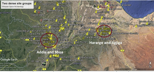
It is now ten years since ‘space archaeology’, or remote sensing applied to heritage management has been introduced to Ethiopia2. Sites I briefly present here constitute the most spectacular discoveries of the period, have created international interest and have part contributed to the onset of research by the British team of Professor Insoll. He excavated scientifically, for the first time sites in Harar and Hararge 3.
This year coincides with an effort to find foreign research partners to excavate a few of the many new sites in Addis Ababa too. Ahmed and I observed that while local led first surveys I strongly supported are not practical for various reasons, uses and conditions favour a foreign led set of research campaigns.
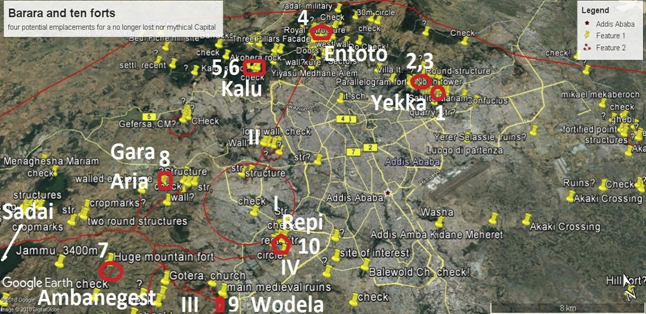
2. Ten forts in Addis, defending and indicating the fief of Solomonic Christian power
2.1 A valuation course lesson: the forts and medieval Addis as a resource
I teach Valuation to building college diploma students at the Italian international school in Addis Ababa. Their curricula correspond to a one year University diploma, and include marginally valuation of heritage and tourist sites. A lesson, this March, centred wholly on medieval Addis, as we attempted to put a tentative monetary value to the discoveries, with the major caveas that sites are yet to be studied, protected and promoted4. In fact, the exercise was intended to illustrate and further document the necessity to stop the continuing neglect and the sites’ consequent ongoing destruction.
I will first introduce ten notable forts recently recovered in our modern metropolis, and in its immediate vicinity.
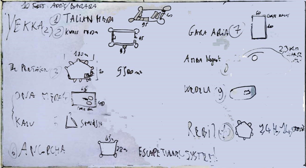
2.2 Yekka and Maganagna forts and villages, a complex Imperial site
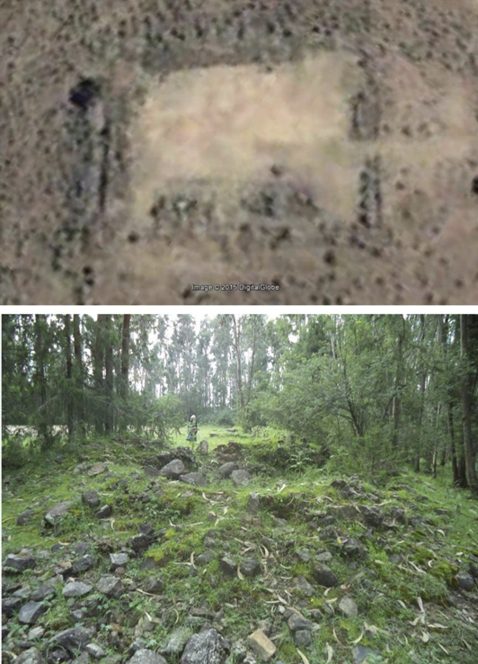
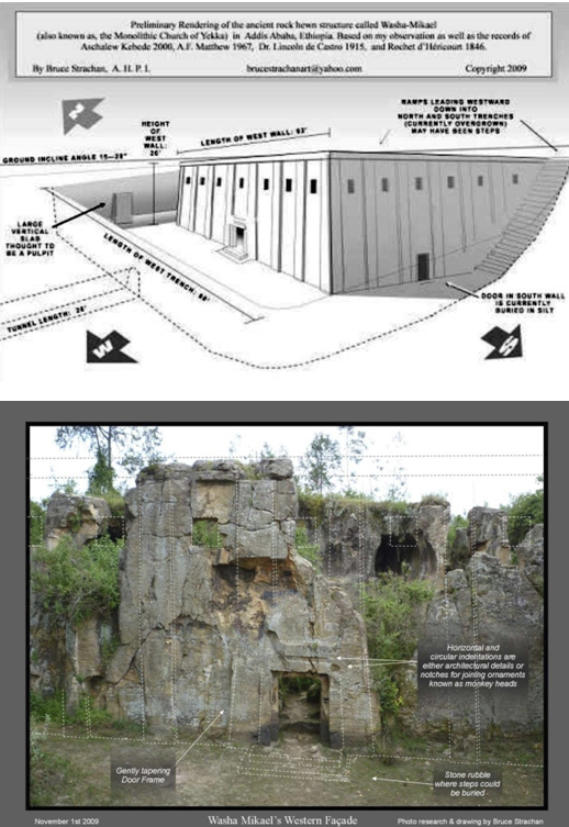
Three forts stand in the Yekka area in Addis Ababa. Together with four villages they suggest Washa Mikael, the vast medieval nine naved unfinished rock hewn Church, attributed to the XV century, in specific to Emperor Zera Yaqob, ca 1430 by local narrative was really no ‘cathedral in the bush’5.
I have drawn the hypothesis Yekka is the Imperial site of Badeqqe6. The Fut’h al Habasha sited it at a day or less walk from Barara7. Ecca or Yekka lies in fact less than twenty kilometers, in a direct line, from the areas we now indicate as the most likely emplacements of the Imperial Capital, from ca 1380 to 1530 CE, the date of the destruction of both Barara and Badeqqe by the Adal conquering army.
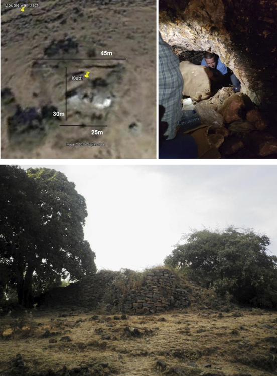
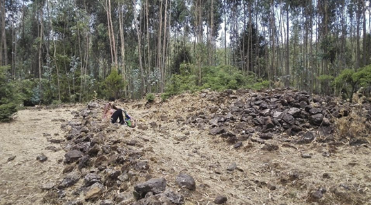
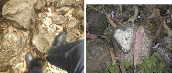
Two forts, Talian Meda and Qwass Meda top the twin heads of Yekka hill. The first is better preserved and includes successive constructions dating from the time of Haile Selasie and a later, external caserne. Set right above a group of Embassies, the Imperial stables and the Asmara road, it remained strategic. A third military structure lies on Maganagna hill, right above the richest villas in Ethiopia, overlooking the East access to the Addis Ababa piedmont. Named Ancorcha kebi, it has a yet unexplored escape tunnel system, unique in equatorial Africa, to the best of my knowledge8. It is clearly seen as a towered fortress on the Fra Mauro planisphere, designed for these parts by residents of Barara and the Zuqwala monastery or in any case, by cultivated locals that represented their world, around 14359. The hill towered by the fort was surrounded by walls, had paved accesses, other structures and areas likely used for training. Two quarries used to build the fortifications have been identified in the vicinity lately10.
2.3 Entoto, the Pentagon and the Royal Citadel
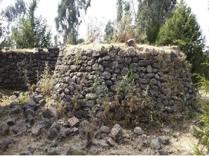
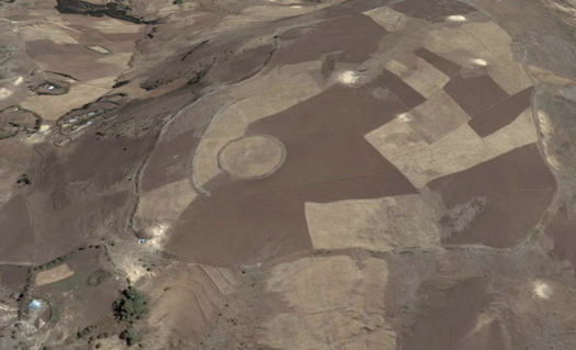
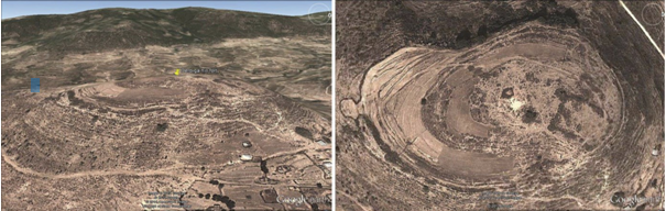
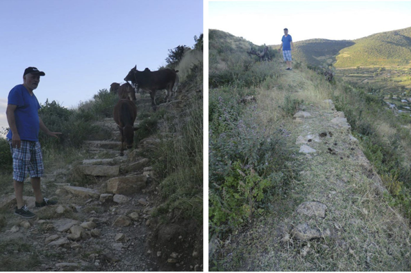
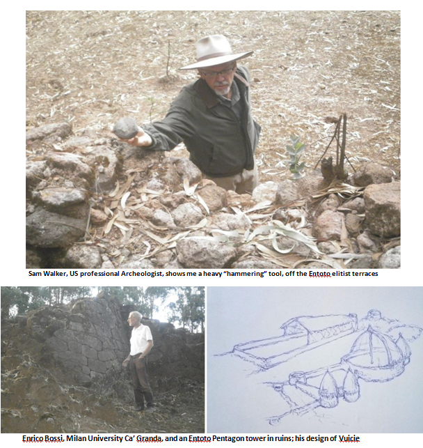
The Entoto crest, as indicated by Minilik’s chronicler Tzafe T’zaz Gebresalase Wolde Qirqos12, hosts a vast three times entrenched and well walled military citadel with residences over about 35 hectares, elitist South terracing residential areas, cemeteries both extremely elitist and ordinary topped by a 9,500 m2 wide pentagonal fort13.
2.4 Kalu hill: two more westerly forts in the Entoto range, the closest to Barara
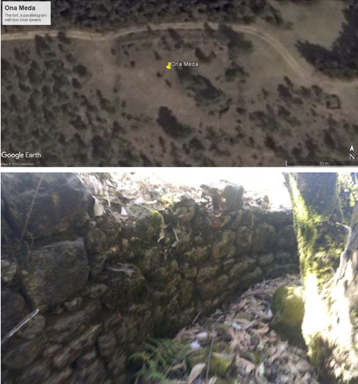
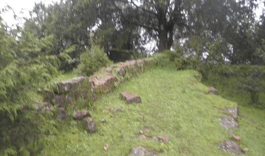
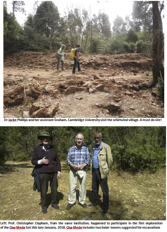
The Gulele botanical gardens, or Meles park, under construction, lodge two forts at the back of the Akobera protruding rock: a) Ona Meda, the last discovered this year, and b) fortifications on Kalu tarara, the nearest to the most likely emplacement of Barara. The gardens as well as the Entoto National Park, still unchartered and under enormous encroachment pressure both by local wealthy figures and the ordinary residents constitute an invaluable asset, if protected and promoted. I argue Addis Ababa has the world unique feature of being contoured by two national parks, both filled with very significant medieval ruins14.
2.5 Mount Wechacha, the Ajos Mons of the middle ages
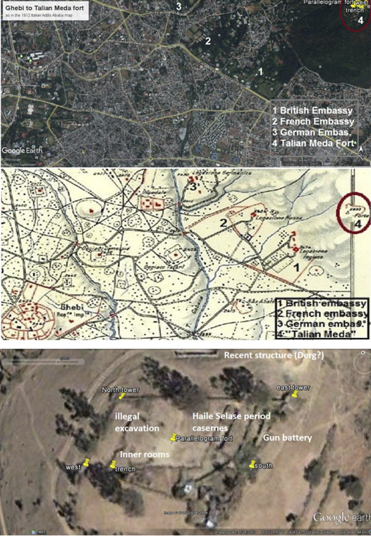
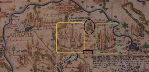
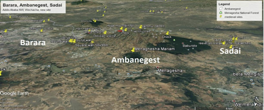
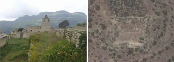
Three more coarse forts top the flat summit and the extreme N and S propagations of Mount Wechacha, clearly seen on the Venetian map as Mount Ajos, a reference I repute to its original Oromo name, Ochos or Ochocha. They are the 2.3km three times walled Ambanegest, of Mountain Fort of the Kings, Gara Aria to the North, above today’s Tatek military academy and the Wodela hill fort, to the South.
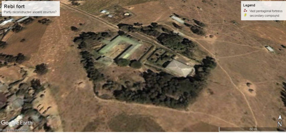
2.6 Repi, a yet mysterious hill structure. Fort number ten?
US colleague, Archaeologist Sam Walker joined me in my research three years ago. His contribution has been vital in expanding north and south of central Shoa our present understanding of the Fra Mauro planisphere. He set on, as many before and me, with me, looking for Barara, with our present understanding, near the eastern slopes of Mount Wechacha, as the map commands.
He soon noted a vast structure on Repi hill, a vast pentagonal fort. We did not manage to approach it directly, as it is the core of a restricted area. It is the vastest of the Addis Ababa forts, over 14,000 square metres wide: a more regular pentagon than the fort in Entoto we attribute to Lebna Dengel Emperor, on the escort of the writings of Gebre Selase Wolde Aregay, accepting his dating to 1515 CE15.
As I will comment further, the area does not appear as the best location for Barara, while the massive fort definitely deserves scientific attention, and potential excavations.
Counting this still not evaluated fort with the others in the area, we thus have three forts in Yekka, one in Entoto, two in Kalu, three on Mount Wechacha, plus Repi: ten fortresses in total.
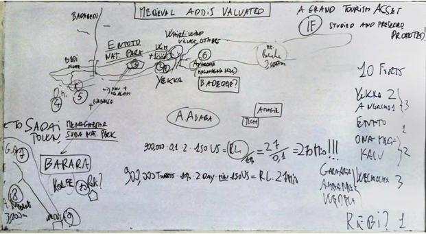
2.7 Valuating millions of ancient cut and laid stones around Addis Ababa, Africa’s Capital
Our estimate was based on the observation that while real international tourists to Ethiopia would not much exceed the number of yearly Lalibela tickets sales, at below 200,000, the last airport entry fiches read around 600,000 tourists, six to seven years ago. These include international family visits, prospective investors, and conference, study and business tourism. Visitors are likely to have significantly increased during these last six years.
Considering Uganda has reached about one million yearly tourists and Kenya is reaching the objective of two millions in the next two years, it is more than reasonable to account for a bit fewer than one million visitors to Addis Ababa, in the immediate future. We estimated there is a potential for two extra days of average stay in Addis, to visit the medieval sites scattered in and around our capital, the continental capital, as the result of study, protection and promotion of the newly recovered sites.
A minimum of 150 USD expenditures is expected per tourist and per extra day of stay. The sum would include hotel, catering, transport, park access and guide costs. Numbers and expenditure form the valuation base and help define the monetary heritage and/or tourism value of a site of any sort.
A rapid calculation on the hypothesis that ten per cent of tourists may visit the sites is reported here:
900,000 x 0.10 x 2 days x 150USD = 27 Mio USD yearly; V = 27/0.10 = 270 Million USD (V: total value). This is the calculation I presented to my students in the second board on page 2 above.
We reputed a capitalizing, valuation from revenue rate of ten percent as appropriate (0.10), considering the rate of return of heritage investment globally and the rates of tourism investments in general16.
The monetary value of a single fort of these ten, taken in their historical context appears to top that of entire compounds of small villas in town today. In effect last year the action of a clever and laudable ARCCH, antiquity authority functionary, engineer Abel Assefa has participated in stopping a rather outrageous speculation attempt in the Entoto Park, one that would have seen the Pentagon replaced by a non better specified ‘resort’. He simply and duly indicated fort and area as a National Monument.
This first monetary estimate does not evidently cover the significance of protecting medieval Addis, or Barara and potentially Badeqqe in historic and national pride value. It is hard to express in other terms than tourism revenue the worth of the unique, mighty power fiefs of a major world power of its time.
2.8 Barara in context, its most likely emplacements
The forts contour and protect the NW sides of today’s ddis. That is where the Fra Mauro map indicated the capital, Barara, stood around 1435 CE. The first identified fort, Ambanegest, divides with the vast Ajos17, or Wechacha volcano the twin cities of Barara, capital, and Sadai, Episcopal city and trade center.
The four areas correspond to hills surrounded by water streams, with the exception of vaster Area I.
Area IV is the Repi hill I mentioned. Though we could not approach the central fort, author and heritage management expert David Michelmore, a prominent member of our research group, combed the area for surface cultural material. We found, literally, none. This appears directly incompatible with the hill being the main Barara area. Rather, the fort would justify the presence of a military garrison or a specific Sire, not extensive and durable settlement. Repi is not Barara, I conclude, but another of its defenses.
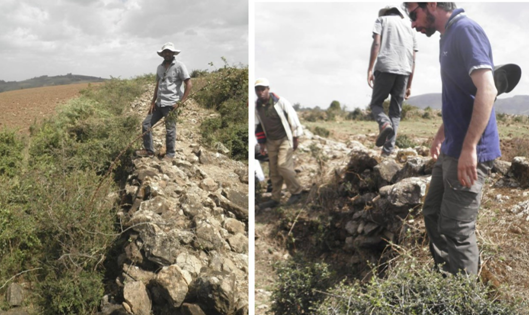
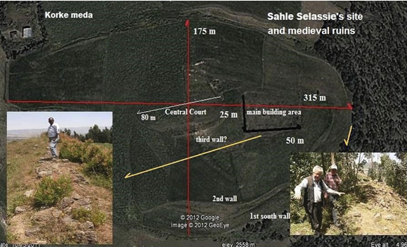
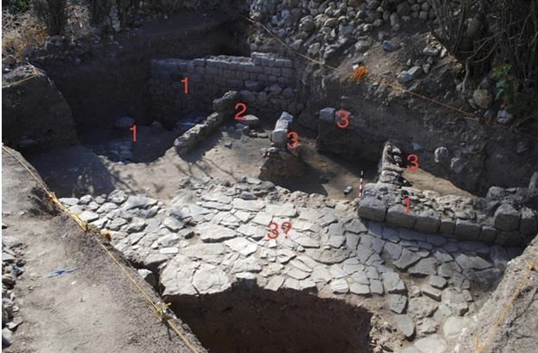
Area III is the Wedela/Korke complex, comprising the described fort (n. 9) and a singular structure, a massive ninety metre wide roofed granary erected around 1829 by Sahle Selassie, King of Shoa. The granary was in service until the late nineteen hundreds, used by Ras Gobena Daichi, according to local informants, whose direct ancestors served on the site. The area is littered with so much and dense obsidian patches and some pottery, to justify it being a town area. But further investigations conducted in 2009-2010 indicated the site was a large and rich medieval Church in the time of “Dawit”, likely the first structure, according to local informants. Thus, this could be an early XIV century site of cult of major proportions.
The presence of a large church would easily explain the concentration of cultural material, so far noted around the fort and the granaries/church, and the same material neither confirms nor excludes the Korke elevated plain could have been the site of the Capital.
Area II is central to Kolfe. A visit there, this very week has revealed the presence of two separate turfs, partly dug and likely partly built, surrounding a large police and military area on the top. Again, access has been so far impossible. The inner turf and potential walls appear to have since long time encircled the hilltop. So far, evaluating their aspect from close by, or checking possible surface cultural material has not been possible.
Areas II and I, my personal best choices to search for signs of a major settlement, are totally overbuilt since some ten years. Most of Area I has been built since long before. I have not managed to obtain, so far, US Coronasat VI and VII imaging from the early seventies. Their microfilm imaging, and possibly Ethiopian administration aerial recognition pre 1990 would be clearly very useful for our research.
We are now not looking for buildings. Considering the lowly walls we found in Sadai, exploring a densely built area in Kolfe, the chances of identifying similar structures are extremely limited.
Rather, trenches, access routes, possibly tracts of eventual external defense walls could be identified18.
Area I has not been explored; unfortunately two structures that appear in the first Digital Globe Quickbird satellite imaging, ca. 2002, were completely overbuilt in the area’s margins by 2010.
Kolfe, a large populated zone in NW Addis appears the best candidate for Barara on the indication of the Mauro map, considering its approximate cartographic distances to the Gojjam and Adwa passes and the vicinity to the Ambanegest fort, as well as its position relative to the Akaki affluent streams in the area. A major, unpublished medieval forge has been accidentally recovered nearby.
2.9 A first survey proposal
Sites we earmarked for first full archaeological surveys are: the Entoto Royal Citadel, the Yekka villages and one of the three forts there, successively the Wedela/Korke plain structures, Repi and Area II.
Sadai and Barara towns appear strongly connected. Their conglomeration, easily sustained by at least two highly productive agricultural areas, in Vuicie and Tich in the period, plus Wedela/Korke itself, a protected high fertility mountain plain, could have easily sustained a combined population above that of Gondar at its peak: over 100,000 inhabitants19. A proposal has been spelled out in the annexed letter author sent to colleague Jan Zahorik at Pilsen University, who enquired on the best lines for immediate research on Medieval Addis Ababa. It includes a minimum budget survey and first excavations
3. Six forts in Hararge and Jigjiga, the coeval equivalent Muslim war technology
3.1 Motives and interpretations of space archaeology finds in Hararge and the Somali State, Ethiopia
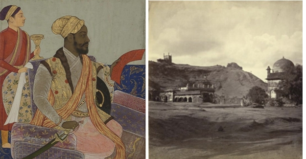
The researchers’ yellow pins, corresponding to sites of interest, mainly reputed to be medieval, concentrate around Addis and the Hararge region, plus its nearby Jigjiga province. The finds bear testimony to the two rival factions: Imperial Christian and the Sultanates, both compelled to mutually advantageous trade, both inland and along the Indian Ocean, but divided by territorial claims and often heavy impositions from both parts. Trade wars occurred, related to land occupations in a balance where the vastly rich and powerful Christians appeared to expand, be repelled and need to negotiate for the indispensible routes to the Ocean and the Red Sea. They finally led to the destructive Ethio Adal war It comes as no surprise, in this context, that both sides possessed very strong, diffused and similar military structures, and absolutely as ordinary feats that Beshi or Sidi, military personnel or freed slaves from Ethiopia encountered brilliant military careers overseas, in India. I would like to mention here only the case of Malik Ambar, born in Harar at the end of the Ethio Adal conflict and soon to become the strong, respected and beloved general and regent of a vast Indian reign, Ahmadnagar.
He was recorded amongst his other feats as the first Indian general to use rocketry in battle, and the builder of a great aqueduct driven by a massive, still visible water driven pump20.
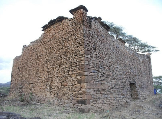
3.2 The Kundudo, Deri and Dire and ancient Hararge forts
Beautiful, isolated Mount Kundudo has been proposed by author, assisted by a number of local residents, as a community reserve. Our initial interest laid in its now largely lost pristine forest, its unique feral horses and the discovery of one of Africa’s best speleological caves, the Gursum Pearl or Holqaa Oromo. Soon, though we realized there laid a medieval mosque on its 13 Ha flat top, ancient burials and some more, still not evaluated smaller ancient structures. The Kundudo, mentioned as a military pass by Samuel Baker on his noted visit to Harar, is indeed the most likely siege of undiscovered Hubat, the town of origin of Ahmed bin Ibrahim the Conqueror and a significant settlement pre-dating Harar. Harar likely became a capital only in the early XVI century, while Dakkar preceded it.
The quest for Hubat, Dakkar and other towns mentioned by local chronics is still open. In the vicinity of elegant Mt. Kundudo, apart from a more recent rather surprising and singularly designed Muslim shrine, lies a fort of similar aspect to that of Qwass Meda in Addis, the Deri structure.
The Dire fort north of the Kundudo and a fort north of Dire Dawa possess the vital common characteristic of being sited on essential trade routes. Those leading to Saylac, the main port of the Adal Sultanate, and to the Somali coast further south. These areas are still, today, busy in the first hours after midnight, being recklessly crossed by speeding pickup trucks of different sorts, exporting perishable and costly chat to Hargeysa and Djibouti. In the times of Hubat, of Dakkar and Harar trade would have been in ivory, gold, slaves and medicines, from Adal, and fabrics, salt spices and finished products from the Indian Ocean trading community. We still have to visit the forts.
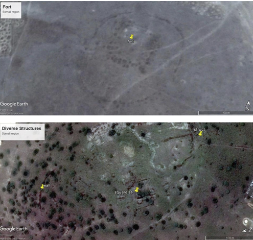
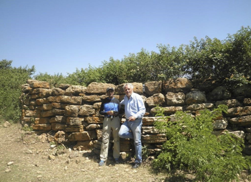
Northwest of Jigjiga and east of the Kundudo, in Hararge, near the medieval town of Chinaksan Francis Anfray excavated but, sadly as often the case, never published21 lies Kocher Derbuga, meaning ‘big stones structure’ in Harari. It is a massive fort and fortified hill complex. We visited it briefly in 2015.
The Kocher Derbuga hill complex dominated a major valley pass between Jigjiga and the Awash valley to the North, dedicated to camel and cattle trade, as well as the mentioned goods import and export. A local informant stated the ancient fort was still in use in the time of Haile Selase, as a garrison manned the valley control fort, considered a border post too with not distant British Somaliland, and a strategic location militarily.
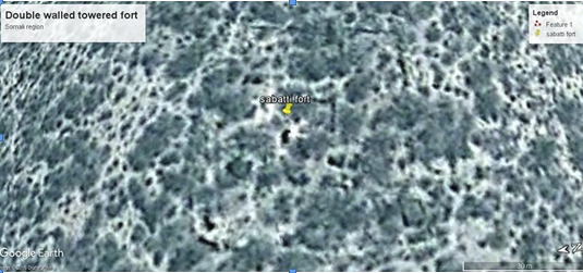
Harari historian and remote sensing specialist Meftuh Shash Abubakar has identified, after the Deri and Dire Dawa forts, also a fortification in Sabatti, starting from travel accounts and XIX century explorer maps. In particular, Paulitshcke transited in Sabatti, describing a fortified hill. This location is further South, opening and controlling trade with mainland Somalia and the Wabi river basin.
3.3 Jigjiga and Finfinne, a common toponomastic, a divided past. Equivalent forts
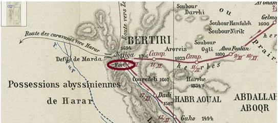
While Finfinne, the original name of Addis Ababa, is an onomatopoeic sound indicating spurting water, Jig jiga means.. exactly the same thing in the local language, Somali. Similarly, on indications from Meftuh Shash, I looked for forts and structures near Jigjiga, where a map produced around 1880 by French voyagers indicated one.
I identified two, I will indicate as Jigjiga forts I and II. We have been so far unable to visit them. Forts and structures in the area, contrary to those in Addis, have been more continuously occupied and renovated.
4. Extension of ongoing research in Hararge
Professor Tim Insoll had at first examined a couple of not particularly revealing sites in Harar, then Hamburti, the Amir Nur Shrine, Shagnila Toya, and the Amir’s Palace in town. Now crucially his group has published on Harla22, a medieval Islamic site known, amongst others to scholar and diplomat Enrico Cerulli since 1929, long described, site of a museum, reported on local tourist guidebooks. His scientific excavations have given reason to local scholars, like Ahmed Zakaria himself, who dated the diffused Harla settlements to the eleven hundreds, over other foreigners who published them as XV century CE structures.
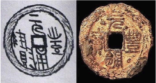
I had myself dated two coins found locally in peasant hands, North Song, to 1040 and 1080 CE respectively23. The Insoll led teams have unearthed more cultural material over and above the artifacts in the possession of locals, and examined by some rescue archaeology, or rather material collection non scientific in proper terms, performed in 1984 by Ato Cherinnet Tilahun.
While the Harla language, last mentioned by Cerulli about eighty years ago has since likely died, the origin of the Harlas, believed to be a main nucleus of the original Hararis, is still obscure. Prof. Insoll’s first datings in Harar confirm what local historians indicate, Harar is likely a XV/XVI century foundation.
I believe Harlas must have been traders, possibly from Iran, as Persia dominated the coast since the slow, protracted fall of Axum, soon reclaiming as theirs all the coastal ports once controlled by the African Empire, from Jeddah to the Southern Somali coast, and all along Yemen and Hadramawt. I have recently reinterpreted as Amharic or Geez fourteen scripts in the Hoq cave, Socotra, Yemen. Socotra Island was a door to the Ocean, and a refuge for doomed, troubled sailors on a much frequented route. It is only logic to understand as Axum, Adulis domain weakened, their Persians rivals would have somehow tried to exploit directly a local main resource. An evident vein of auriferous, gold bearing quartzite outcrops in higher Harla town. I inspected it with a professional British Gas resource geologist.
Locals pointed that similar, excavated veins lie nearby, and crucially, in other of the nine Harla villages in the area. It is logic to infer directly that Harlas resided to exploit the gold, and that their rather ephemeral civilization must have been tied to the mines. Genda Harla is the other prominent site examined by the British, Exeter University team. It presents megalithic enclosures, and an ancient cemetery, residences. Here too residents pre date it to the nearby Sofi Shrine, of the XIV Century.
5. Integration of historical and geographical reconstructions: a tale of medieval might and war, the Great Sultanate and the Empire
Remote sensing and simple site walking visits have since a number of years drawn parallels and differences between two tied, yet contrasting cultures. Much like Kemet Egyptians and Nubians, later Axumites competed and shared culture and other resources along the Nile valley and basin the middle age Solomonic Empire and the grand Adal Sultanate traded, shared and fought around the Awash rift, and across the plains and escarpments between the highlands and the coast.
As Cerulli noted, it was a trade with changing loads, from the camels to the donkeys, on the escarpment near Alihu Amba and at other locations, not far from the still standing homes and mosques of Ifat, the other major Sultanate of the times. Asberi, Mesal, Goze, Muslim outposts and, in reality, the contact with wealthy Christian societies organized under local, rather elastic and prosperous feudal systems.
The routes, the languages, the still unexplored sites and cultures along these trade routes invest a great interest, to attempt complete historical and geographical reconstructions of one of a few African massive, world encompassing civilizations. One civilization, as today a new generation of Ethiopian politicians tend to stigmatize, in spite of an often divided past. A common history based essentially on inland to Ocean and Red Sea trade, and the derived might more recent colonial scrambles have
rendered hardly manageable, politically.
6 Intelligent Afrocentrism: a contribution to understanding a denied past, roots of new developments
This brings me to debate briefly my very short experience at studying and promoting the recognition of African History. Redressing at least two centuries of Eurocentrism and blatant racism driven historical and geographical narrative necessarily requires a form of Afrocentric answer.
Unfortunately, so far Afrocentrism has been felt as an Afroamerican practice, centred on demonstrating that “They came before Columbus”, where curiously in the rather ill defended theses of Ivan van Sertima, they or the third person plural is exactly the Africans, that, well demonstrated, reached with very few exceptions the whole of the Earth, as Homo erectus, so much like us if not us, well before, in fact hundreds of thousands of years afore we developed in the Rift and a few other African locations as Homo sapiens. African genes were of all sorts and colours of skin, that all important feature͙
And sure us humans occupied the planet, aided in our supremacy over other Homo and predators by a power developed here some seventy thousand years ago, language, the word, and became unstoppable communicators, as much as a scientific.. threat to a natural, not anthropoid, man imagined world.
While an Afrocentric approach is a clear must, to dispel the lopsided and totally wrong historical perspective that widely prevailed until the last twenty years or so, illogic mistakes must be avoided.
There is no need to concentrate on the African origin of the Olmec civilization, unfortunately.. we cannot DNA test megalithic heads, there is little solid science in general appearances to prove origin without doubt, no doubt rather that pre Clovis South American civilizations came albeit accidentally from West Africa, rather, Afrocentric scientists should DNA test Luzia and similar clearly African character skull and human, Homo sapiens remains in the Brazilian Sierras.
We need to be precise, to avoid being ridiculized whenever an Afrocentric US scholar modifies the narrative to adapt weakly founded affirmations to reality. Like when van Sertima modified his texts or as logic ridicule covered the ‘Cocaine and Tobacco’ Egyptian mummy theories.
Intelligent Afrocentrism stems from, and produces results in Africa, starting when we accept with all serious scholars that Africans were the Origins of Kemet Egypt, before the 535 CE Persian invasion or the Greek and Roman periods. Since Champollion non colonial historian accepted perfectly that ancient Egyptians depicted themselves in a Nilotic morph and colour, that the Nile is their civilization and P’wunt, or today’s Eritrean and Somali horn coast was their Land of Origin and of the Gods, Ta Net’jer.
There is racism of the colonial strain in declaring civilization, the real achievement of mankind, arose in the river valley of Mesopotamia, the Indus, ‘EGYPT’ and not in the Nile valley, and just perhaps in the Yellow river too. The conflicting, trading and alternatively dominating peoples of Kemet, Nubia and Axum were one global civilization, as much as the traders that dominated the world seas in the first sea koine, or globalization in the times of the Phoenicians were under the control of the Egyptian Empire.
Most would recognize that the ‘middle east’ or ‘fertile crescent’ Empires, for one the Kemet and Hittites were in fact one global civilization, warring at times over the control of the sea, land and above all trade resources, but intermarrying and forging steady alliances. That was the period when Ugandan tin
guaranteed safety for the still undeveloped North German tribes, some 3300 years ago, as it produced heavy but solid bronze swords23. Africans brought it to other Africans along the oceanic African coast, the Egyptians and their affiliates and subjects Phoenicians, the admirals of Kemet, diffused it worldwide, from the North African coast.
New methods and disciplines, serious coordinated interdisciplinary efforts must study, develop and promote the now popular study of medieval Africa. The trade routes of earlier and medieval periods should be approached in international multi-year programmes of tied research projects, on the model of the UNESCO African Iron study that created much resistance, and disbelief, as bible-thick pages of publication showed without a benefit of doubt that Central Africans in “uncivilized” primitive forests produced the first iron quality forges and fathered, over 2400 years before, the technology of the Benin bronzes one can admire in colonial powers museums and tourists can see produced, today by the same guilds, with the same technology and craftsmanship, in Nigeria.
There is not much scope in debating on those black Africans de las Casas and Columbus met in Haiti, Hispaniola and their gold alloy lined arrowheads, until we do the nautical archaeology and find the African, generally sewn planks ships that crossed the ‘oceans green’, as the Malian Emperor, the outrageously rich Kankan Musa called them from his Gambia river ports. Of course they got everywhere, since dozens of thousands of years before the age of European colonization and exploitative conquest.
Unfortunately a German scrap metal recycler, not a nautical archaeologist found an entirely African wood sewn plank ship off the Sunda straits, so he destroyed the ship to recuperate rapidly its cargo. It was an African ship, I claimed, the inheritor of the three military Axumite fleets, uncountable Adulis trade flotillas reaching India and beyond. We have found, at least one IV or V century Axumite cargo neat Adulis, the Black Assarca wreck.
Inheritors of the Kemet Phoenicians ship makers continued for 3,000 years to trade across the same route that brought tin from Uganda to northern Europe, since the Bronze Age of the Uluburun shipwreck, loaded with precious cargo from ten states and about fifteen ports.
The future of African historiography is in reconstructing geographically its oceanic and land routes, with new tools like earth observation and HD synthetic aperture sonar, DNA testing and sophisticated non invasive dating, microRahman scans and isotope characterization of the sort that permitted the identification of tin in Germany as Ugandan, and the analysis of sea and fluvial African port structures. Of the kind that brought Rodolfo Fattovich and Kathrine Bard to understand the dismountable Egypto-Phoenician ships, over 3500 years old, used regularly between the Mediterranean and the Eritrean
coast. These will be combined with classic field archaeology, the toolkits of the geographers, historians as well as linguists, anthropologists, space archaeos, paleobiologists and geomorphologists that build a team today.
The towns, forts of what persistently European culture adopted as the “Preste”, his rivalry with the “Sultan” with his own forts, towns, ports and routes are to me just a piece in a global history we can and should rewrite from the Seas. One where Africa was never the black hole impeding trade or development, but the origin of it all: trade, the oldest pottery, writing, and the most powerful shared civilization. The one of the Nile valley, that developed and thrived off its seas and river and desert trade routes.
Where, now, diffused forgotten military and civil structures of size, trade towns, capitals, hamlets and citadels, cult sites, are revealing life styles and global connections. Definitely enough to render revolutionary, history changing research well worth the effort.
References
1. Harar has been declared a UNESCO heritage site in 2006. The presence of its original walls and its pristine status has been the determining factor in the site evaluation and attribution.
2. Space archaeology was introduced in 2008 by a small team of researchers, led by author, cfr. my specific section on academia.edu: https://addisababa.academia.edu/MarcoVigano#medievalethiopiarecovered
3. See e.g. Insoll, T, Khalaf, N, MacLean, R., Degsew Zerihun, 2017, Archaeological Survey and Excavations, Harlaa, Dire Dawa, Ethiopia January-February 2017. A Preliminary Fieldwork Report. Nyame Akuna, 87
4. Apart from the Entoto Royal Citadel, repeated attempts to have the sites mapped and protected have so far failed. The administration, after the discoveries in Addis made headlines and a video on Entoto has been seen and shared online around ten thousand times declared via the media they were aware of the sites, yet e.g. the whirlwind village, a major feature has been wiped out, with at least half of its houses bulldozed to pass a power line in 2017.
5. I put Washa Mikael in the context of the massive Yekka sites in Vigano, M., 2014, Due passi a sud di Washa Mikael, academia.edu, cfr. also: https://www.academia.edu/29431642/Per_non_Esserui_Logo_For_Lack_of_Space._Why_we_s
hould_be_studying_protecting_and_promoting_Medieval_Addis_Ababa , and in other papers in the Medieval Ethiopia Recovered section of my academia page.
6. I claim Yekka with its three major forts, a military citadel, four villages and Washa Mikael is a major Imperial site. Ecca and Badeqqe have a clear assonance. Cfr.: Vigano, M., 2015, The Names Lost, the Map Grasped Central Shoa on the Fra Mauro map, is significant lost medieval Ethiopia recovered?, p. 16-17, 27 academia.edu
7. Sihab ad-Din Ahmad bin Abd al-Qader bin Salem bin Utman, The Conquest of Abyssinia (Futuh Al-Habasa), Cesare Nerazzini translation, La Conquista mussulmana dell’Etiopia nel secolo XVI, Roma, Forzani e C., 1891
8. I published a description of the Ancorcha fort and related Meganagna hill structures in this online paper: https://www.academia.edu/31675506/Ancorcha_a_fourteenth_or_early_fifteenth_century_fort
9. Sauter, 1957 published the site, reporting a conversation amongst locals attributing it to Zer’a Yaqob. Sauter, R., L’Eglise monolitique de Yekka Mikael, Annales d’Ethiopie, 1957, II, pp. 15-36. Online at Persee.fr, http://www.persee.fr/web/revues/home/prescript/article/ethio_0066 2127_1957_num_2_1_1256
10. Vigano, M. see ref. 8, ibidem
11. Bruce Strachan studied Washa Mikael since around 2004 and published on it on a personal, updated dedicated blog: http://washamikael.wordpress.com/
12. Tzaf T’zaz Gebre Selasie W/Aregay, Tarika Zemen Ze dagmawi Menelik Neguse Negest Ze Yitiopia, translated into French by Blatta Merse Hazen Wolde Qirqos, Artistic P. Press, A.A., 1959.
13. See my study on the Pentagon in Entoto, starting from three 1897 photoes of a major structure along its SW ramparts: https://www.academia.edu/30552555/The_Missing_Tower_At_the_Entoto_Royal_Citadel_in_three_photographs_from_1897
14. I have published a suggestion on the much needed chartering of the two national parks near and within Addis Ababa, describing how and why they must be considered archaeoparks: Vigano, M., 2017, Urban National parks within an African Metropolis, academia.edu, 2017, p.6
15. The capital value of a good evaluated for its revenues is the quotient of the yearly revenues, here retained as gross, as the expenditures are all made in Ethiopia, and a rate, named as capitalization rate. The latter depends on the kind of good, market conditions and is evaluated separately. Ten per cent is a high estimate, a lower rate, that considers revenues safer, would increase the site value. It is on the other hand conjecture that one out of ten of 900,000 foreign visitors would visit the sites. This depends on opening on site museums, activities and their promotion, including the mentioned missing proper chartering of the two Addis Ababa area national parks. To the purpose, I printed a guide to medieval Addis, Barara by Bus. It indicates one to three day tours. It could not be marketed as it would heve exposed the unprotected sites to further degradation. Available to scholars on demand to author at about one euro, local print.
16. Tzaf T’zaz Gebre Selasie W/Aregay, Tarik…, ibidem
17. Ajos Mo.s, appearing on the map is not registered on the Piero Falchetta transcriptions, that include 2912 items, but evidently still fail to record all writings on the planisphere. It must be noted our team has, really, fully exploited over the last eight years at least the map, producing vast and singular research on it. Indeed we can state no other single artifact has so far produced so many advances in Ethiopian studies. Cfr. Falchetta, Piero. Fra Mauro’s World Map. A History. Biblioteca Nazionale Marciana, Venice, 2010.
18. Deep trenches and lowly walls are the major structures of Sadai, cfr.: https://www.academia.edu/30095282/Sadai_stelae_town._Ambanegest_mountain_of_Kings._Of_the_fief_of_Solomonic_power_of_a_passion_for_pentagons_and_other_amenities_in_Medieval_Ethiopia_comprising_the_worlds_first_National_Park
19. Explorer James Bruce evaluated Gondar house numbers at around 8,000 in the XVIII century, this means likely over 70.000 inhabitants. Barara was presumably vaster, considering the wealth and land masses, at least double, the Empire commanded in the late XV century. Barara, Sadai and Badeqqe combined would have easily passed the 150,000 inhabitants mark. My paper in note 18 above calculates just two areas: the Tich plain, indicated on the Mauro map, and Vuicie we found and explored this year could sustain a similar or superior population. Cfr.: https://www.academia.edu/26052539/The_shapes_of_medieval_Addis_Ababa, p. 15
20. Malik Ambar, see the Wikipedia entry: https://en.wikipedia.org/wiki/Malik_Ambar
21. Teshager Habtie, historian, Gondar and AA Universities, personal communication
22. Timothy Insoll, see ref. 3, ibidem
23. Dayton,2002, Central Africa as a source of Phoenician tin. In Proceedings, 33rd Symposium on Archaeometry. Geoarchaeological and Bioarchaeological Studies 3. Ed. H. Kars and E. Burke. Institute for Geo and Bioarchaeology. Also cfr.: Vigano, M., 2016, African circumnavigation by
Africans. Carthaginians discover Mount Cameroon, the Ugandan tin Phoenicians sold in Europe Two thousand years old African lighthouses in the Mediterranean and North Atlantic, p. 32
24. Two Chinese coins in Harla have been dated by Vigano, M. with assistance from Chinese scholars, cfr.: https://www.academia.edu/2566792 /Northern_Song_coin_finds_in_Harla_Ethiopia_point_to_newly_found_silk_routes_from_China_to_the_Horn_of_Africa
Thirty useful reads
1. Almagia’, Roberto, Il mappamondo di Fra Mauro, facsimile ed. (Rome, 1956).
2. Alvarez, F., Verdadeira Informacem das Terras do Preste Joam das Indias, segundo vio e escreueu ho padre Francisco Alvarez capella el Rey nosso senhor. Lisboa, Casa de Luis Rodriguez, 1540.
3. Anfray, F., Autour du vieil Entotto, Annales d’Ethiopie, 1987, XIV, pp. 7-12. Online at Persee.fr, http://www.persee.fr/web/revues/home/prescript/article/ethio_0066-2127_1987_num_14_1_929
4. Anfray, F., Enselale, avec d’autres sites du Choa, de l’ rsi, et un ilot du lac Tana, Annales d’Ethiopie, Vol. XI, 1978.
5. Borelli, J., Ethiopie meridionale, Journal de Mon Voyage Aux Pays Amhara, Oromo et Sidama, (Ed.1890).
6. Breternitz, H. and Pankhurst, R., Barara, the royal city of 15th and early 16th century (Ethiopia): medieval and other early settlements between Wechecha Range and Mt Yerer: results from a recent survey, Annales d’Ethiopie,Volume 24. p. 209-249, 2009.
7. Cattaneo, Angelo, Fra Mauro’s Mappa Mundi and Fifteenth-Century Venice, Terrarum Orbis, Brepolis Publishers, 470 pp.
8. Cerulli, Enrico, “Fonti arabe del mappamondo di Fra Mauro, ”Orientalia commentarii periodici Pontifici Instituti Biblici, Roma, nova series, IV (1935), pp. 336-338.
9. Cocquery.Vidrovitch, C, Histoire des villes d’Afrique noire: des origines a la colonisation, Albin Michel, 1993, pp. 412.
10. Crawford, O.G.S., ed., Ethiopian Itineraries ca. 1400-1524, including those collected by Alessandro Zorzi at Venice in the years 1519-24, Cambridge University Press for the Haklyut Society, pp.195.
11. Falchetta, P. Fra Mauro’s World Map: A [new] History, http://www.academia.edu/9720850 /Fra_Mauros_World_Map_A_new_History
12. Tzaf T’zaz Gebre Selasie, Tarika Zemen Ze dagmawi Menelik Neguse Negest Ze Yitiopia, translated into French by Blatta Merse Hazen Wolde Qirqos, Artistic P. Press, A.A., 1959.
13. Gleichen, Count Albert E.W., With the Mission to Minilik, 1897. London, 1898.
14. Heldman, Marilyn E., Chalice from Venice for Emperor Dāwit of Ethiopia, Bulletin of the School of Oriental and African Studies, University of London Vol. 53, No. 3 (1990), pp. 442-445, Cambridge Un. Press.
15. Mohammed Hassen, The Oromo of Ethiopia: A History (1570-1860), Trenton, Red Sea Press, 1994.
16. Huntingford, G. W. B., The historical geography of Ethiopia from the first century A.D. to 1704. Edited by Richard Pankhurst. Ethiopic spellings revised by David Appleyard. (Union Academique Internationale. Fontes Historiae Africanae. Series Varia iv.) xlix, 311pp., 20 maps. Oxford: Oxford University Press, for the British Academy, 1989.
17. Kammerer, Albert, La Mer Rouge, l’ byssinie et l’ rabie depuis l’antiquité (Le Caire, 1929-52), vol. I, pp. 374-387.
18. Krebs, Verena, Windows onto the world: Culture Contacts and Western Christian Art, 1400-1550, forthcoming. Abstract: https://www.academia.edu/3683786/Windows_onto_the_World_Culture_Contact_and_Western_Christian_Art_in_Ethiopia_1400-1550
19. Powell Cotton, P.H.G., A sporting trip through Abyssina, 1902, reprint, Kessinger Print, 2009,pp. 564.
20. Pankhurst, R., History of Ethiopian towns from the middle ages to the early nineteenth Century,Weisbacher, 1982.
21. Pankhurst, R., The Ethiopian Borderlands, Lawrenceville, Red Sea Press, 1997.
22. Ricci, L., Resti di antico edificio in Ginbi (Scioa) Annales d’Ethiopie, Annee 1976, Volume 10 Numero10, pp. 177-210 http://www.persee.fr/web/revues/home/prescript/article/ethio_0066-2127_1976_num_10_1_1169
23. Strachan, B., Washa Mikael, an overlooked African Treasure, http://washamikael.wordpress.com/
24. Sauter, R., L’Eglise monolitique de Yekka Mikael, Annales d’Ethiopie, 1957, II, pp. 15-36. Online at Persee.fr, http://www.persee.fr/web/revues/home/prescript/article/ethio_00662127_1957_num_2_1_1256
25. Sergew Habte Selassie, Bibliography of Ancient and Medieval Ethiopian History. History Department Haile Selassie I University, 1969.
26. Sihab ad-Din Ahmad bin Abd al-Qader bin Salem bin Utman, The Conquest of Abyssinia (Futuh Al-Habasa), Cesare Nerazzini translation, La Conquista mussulmana dell’Etiopia nel secolo XVI, Roma, Forzani e C.,1891.
27. Tedeschi, S., L’Etiopia di Poggio Bracciolini, Africa: Riv. trimestrale di studi e documentaz. dell’Istituto italiano per l’ frica e l’Oriente Anno 48, N. 3 (settembre 1993), pp. 333-358.
28. Tubiana, J., L’Ethiopie moderne: de l’avenement de Menelik II a nos jours, Balkema, 1980, pp. 556.
29. Vigano, M., What of medieval Archaeology in Ethiopia? The quest for Barara, a plan for archaeological urgencies, Academia.edu, 2010, pp. 14. https://www.academia.edu/2566166/What_of_Medieval_Archaeology_in_Ethiopia_The_quest_for_Barara_a_plan_for_archaeological_urgencies
30. Weber, Benjamin, Gli Etiopi a Roma nel Quattrocento: ambasciatori politici, negoziatori religiosi o pellegrini?, Mélanges de l’École française de Rome – Moyen Âge http://mefrm.revues.org/1036
Annex I
A letter to Jan Zahorik, Pilsen University, Prague Science Academy and other interested researchers Including a first research proposal for the Addis Ababa sites alone.
Dear Dr.Jan and Professor Gabor, Dear All,
I take this chance to indicate some preferable paths for further studies. Here are my ideas, as I had
promised to Prof. Gabor, and after the proposal by Jan Zahorik during our brief but dense meeting
yesterday, to follow up my initial research with excavations and verifications of my first claims.
The objective is medieval Addis Ababa, on the escort of a few years of:
1- Ancient map interpretation, chiefly of the Fra Mauro map, designed for vast African expanses by Abyssinian monks: a reliable representation of their world, that has come to extend Shoa and near Ethiopian territories to cover a͙. sixth of frica! The map appears to be correct to a few miles in tracts and is the only, invaluable tool to find and name unknown or non understood sites.
2- Satellite views, mainly covering the areas the map indicated as towns and otherwise occupied, once I managed to ‘crack’ the map code around ddis and place correctly all its main physical features. Sam Walker has since enlarged the comprehended map parts.
3- Field visits and first site and site interrelations, first non peer reviewed publications As it is evident that at least two dozen very significant sites lie in a radius of some thirty kilometers from Addis Ababa, partly within the town limits and partly just outside them, the capital can serve both as residence and study field and help our local colleagues build much needed and lacking field experience. We can help AAU devise how to start setting up, later in the process, a field school for archaeology and applied history. During a second campaign, or after the first, local results publications and public sharing should be envisaged to foster use and protection of the sites.
Cfr. my suggestions on the ‘uses’ of Medieval Addis: https://www.academia.edu/29431642/Per_non_Esserui_Logo_For_Lack_of_Space._Why_we_should_be_studying_protecting_and_promoting_Medieval_Addis_Ababa
Site and architectural typologies include
1 – Ten major mountain forts generally associated at first glance to the medieval Christian splendor period 1350-1550 CE, the ‘ ge of Barara’. They stand in definite groups, protecting passes and around where our group of researchers believes Barara herself was, in NW Addis Ababa. In at least two cases, in Yekka and Entoto, the forts are associated with elitist and ordinary residential areas, and appear to stand as military citadels, surrounded by massive trench systems.
2 – Four villages in the Yekka valleys, that explain the presence of massive nine-naved Washa Mikael Church as no ‘cathedral in the bush’ but as expressions of a massive Imperial 15th century settlement.
3 – Thirteen churches, all within the town limits and re-appropriated by the clergy, are largely overbuilt and difficult to single out as ruins, also, improbable as a first excavation choice. Science is evil, to clergy!
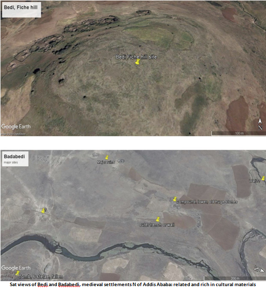
4 – At least three peripheral, largely rural villages or small towns in the N, SE and SW directions from Addis/Barara. My suggestion would be planning a first visit to choose excavations sites, also potentially via the use of non invasive survey technologies, mainly georesistivity, thanks to its characteristics and to the availability of a Sardinian academic with site scan experience and an instrument. I indicate the villages within Addis, Yekka in particular would be the priority, together with Vuicie, Bedi and Badabedi peripheral rural towns. As, logically, not often lived in forts would yield fewer results.
The Entoto Royal Citadel is a vast, likely later (1515 CE according to Chroniclers) interesting objective. Its 35 hectares approximately of ruins command attention and the selection, during a visit, of the elitist “palace” and of at least two of the three identified cemeteries, one of which Royal in nature.
The same Entoto site has a terraced residential area and the occupied soils N of the Pentagon, the one hectare wide impressive pre-stellar fort. I suggest both be evaluated for phase two and three excavations. In the area, a cemetery appears to be related to the same site and periods.
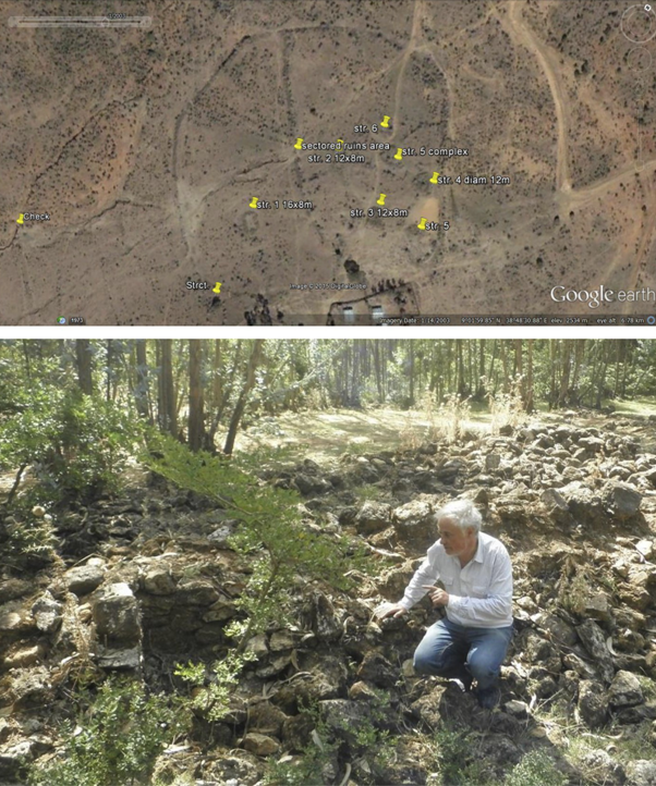
Pls check as reference my Academia page specific section, also to further knowledge on the new sites: http://addisababa.academia.edu/MarcoVigano e.g. Vuicie, discovered very recently is intact, untouched like others here, a primary site, and has some smaller rooms that may suggest concentrated results, in one or two say 4x2m phase two test pits. Cfr.: https://www.academia.edu/35434459/Vuicie_A_rural_border_hamlet_in_medieval_Abassia_pre-dating_1430_CE
A few notes in preparation of a minimum budget.
The apparently inescapable habit of awaiting foreign funds to conduct any archaeology in Ethiopia is hard to break. I have long been trying to elicit local led excavations, by AA University, with the relative permissions by the competent authority, ARCCH. It appears that while the latter is ready to give due permissions, colleagues feel they are either not in a measure to conduct them, or fear others, criticism.
In a near past related institutions, both at federal, local states and local administrations have imposed irrational requests to visiting scholars, ranging from asking for 4WD vehicles for their respective offices and, as logic, perdiems (25 US per day) for personnel, at times non competent, accompanying the teams.
While the first is waivered, perdiems for at least one ARCCH officer are needed, while the free participation of Archaeology and other students from AAU is likely easily obtained.
There is a specific form from ARCCH I am acquainted with, easy to fill, requiring the signature of a
leading and an accompanying academician, say a director of research and other, necessarily a PhD in Archaeology if excavations are implied. This is processed, if.. I go and follow them up, in about 3 months. The observation that precious little archaeology is active today indicates I would expect offices to be ready to cooperate, some perdiems being today particularly welcome to us all.
My first and very wide guess would be some 15,000 Euro would cover, tentatively:
– AR tickets from Europe, for four/five participants and relative tourist visas (three months): 3000 EU
– Average accommodation in Addis Ababa in BB, daily catering, often sandwiches for the field and suppers, over 21 days: 5000 EU
– Perdiems of locals, transport to the sites (location of a town car for 21 days), local transports for possible assisting students: 1000 EU
– Some complementary local material, stationery: 100 EU
- Other, unforeseen: 500 EU
Complement to total budget: salaries and stipends of main/foreign participants.
Understand this is meant to be a very limited budget first research, intended to foster wider successive financial participation. Possible availability of more funds could permit a much needed further first survey of more sites. We will need a comprehensive base survey of the large area, at an early stage.
mv, Addis Ababa, Jan 23rd, 2018